DS#3 - "Zemgale Region" (Latvia)
This page is also available in Latvian ![]()

Location
Zemgale region, Latvia
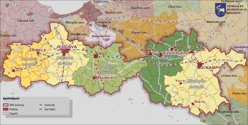
The demonstration site, the Zemgale region, is located in the central part of Latvia. It concerns a rural/agricultural area (biogeographical type: Boreal) with an approximate area of 10742km2 (16.6% of Latvia).

© Zemgale Planning region

Description of the area
In a nutshell:
- Lowland landscape (flat terrain, dense river, subsurface and surface drainage network)
- Fertile soils, intensive agriculture land, large-scale farming, cattle-breeding and poultry farming activities (the location of largest egg production enterprises)
- Low population density within rural area of the region
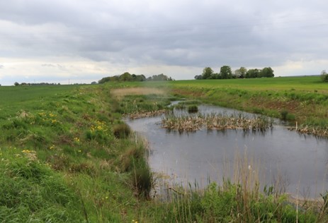
The Zemgale Region is located in the central part of Latvia. It constitutes a lowland landscape that is characterized by flat terrain and a dense river network, which provides ecological corridors essential for biodiversity and recreational opportunities for people. Zemgale is crossed by 2 major rivers: Daugava and Lielupe. The water resources in the region provide sufficient water for economic activity and human consumption. The drinking water supply is ensured by a groundwater supply source. Because of fertile soils in the Lielupe River basin territory, this area has developed into an intensive agriculture land where large-scale farming dominates. Agricultural activities are well developed and focus on the cultivation of crops. Because of the flat terrain landscape, the region is characterised by high flooding risk potential.

© Dace Strigune BEF Latvia

Climatic Challenges
During the last decade, the area of croplands has increased while meadows and pastures have been reduced putting pressure on grassland habitats. This has led to a decrease in biodiversity as well as pollution of water bodies by nutrient leakage from agricultural land resulting in eutrophication problems. Thus, the interest is to apply constructed wetlands as a solution for diminishing of eutrophication of water bodies along with maintenance of biodiversity and flood risk mitigation.
Moreover, the low population density within rural area of the region is characteristic. NBS as constructed wetlands for treatment of wastewater from these small settlements can be seen as an option (as compared to a grey infrastructure WWTP).

Planned activities
Operational constructed wetland for treatment of diffuse pollution from agricultural fields :
- Baseline assessment
- Water sampling/ analysis
- Counting of species
- Adjusting operational conditions, monitoring
- Estimating effects & results
Preparatory actions and roadmap on the potential for constructed wetland on treatment of pollution from point sources
- Mapping pollution sources
- Water sampling analyses for baseline, site selection
- Design and constructed wetland for livestock facility and small settlement
- Establishment of constructed wetlands
- Adjusting operational conditions
Systemic and targeted planning for Nature Based-Solutions in the region:
- Estimation of the problematic areas in need for NBS, geographical scope & locations
- Demonstrating the process for NBS implementation
- Plan/feasibility study for potential financing the application

Ambition
Ambition during the project
- increase awareness among stakeholders involved in water management about the potential of constructed wetlands to reduce nutrient losses to water bodies, meanwhile minimizing undesirable consequences of drought and flooding conditions and improving biodiversity. The DS shall increase the acceptance of constructed wetlands as a relevant wastewater treatment solution among the public and stakeholders involved in water management and decision-making processes. It shall also facilitate financial support for broader implementation of this solution. This ambition will be achieved through dissemination of the project results in public events with stakeholders and meetings with the Ministry of Agriculture and the Ministry of Environmental Protection and Regional Development,
- selection of suitable locations for the implementation of constructed wetlands to treat municipal wastewater from small settlements and storm water and/or processing wastewater from livestock facilities. The ambition will be achieved by sharing the monitoring results and experiences from already existing constructed wetlands and by creating a list of criteria that can be applied to select suitable locations for implementation of constructed wetlands to treat wastewater leaving municipal WWTPs and livestock facilities and runoff from agricultural areas,
- assess the performance of constructed wetlands in the light of climate impacts and hazards by applying modelling tools.
Ambition after the project
The expectation after the project is to achieve large scale implementation of NBS and subsequent improvement of the water quality and the increase of biodiversity. Identification of areas (sites) for potential establishment of constructed wetlands in the region shall enhance wider uptake of constructed wetlands.

Involved partners


